
Everest’s Khumbu Icefall Just Re-opened After 19 Days
Most people assume Everest gets more dangerous every year. More climbers, more crowds, more risk. The data says otherwise.
A study out of Harvard Medical School, published late April 2026, found the death rate on Everest has been cut in half over the past two decades. Better weather forecasting, fixed ropes the full length of the standard route, improved oxygen systems, and stronger teamwork between climbing teams have all played a part. The mortality rate is now 0.7%, down from 1.4% recorded between 1921 and 2006.
Timing-wise, that study landed right as the mountain made headlines for a different reason. On April 28th, 2026, the Khumbu Icefall route reopened after sitting blocked for 19 days. A massive chunk of glacial ice had collapsed onto the only viable path above Base Camp, stopping over 400 permitted climbers in their tracks.
The route is open now. The season is underway. And if you have had Base Camp on your list, this is your most complete guide to what you are actually getting into.
What Happened on the Mountain This Spring
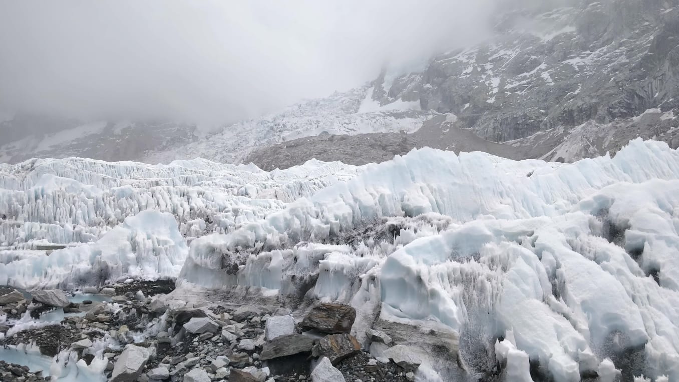
Each spring, before a single expedition team moves up, a crew called the Icefall Doctors goes first. Their job is to build the route through the Khumbu Icefall, the section of glacier above Base Camp that every Everest climber has to cross. They fix the ropes. They lay the ladders over crevasses. They do this in the early morning hours because that is when the ice is most stable.
This year a serac, a block of glacial ice, fell directly across the standard path. Not a small one. The kind that sits there and makes you rethink your plans. No ropes could go past it. Four hundred plus climbers set up tents at Base Camp and waited.
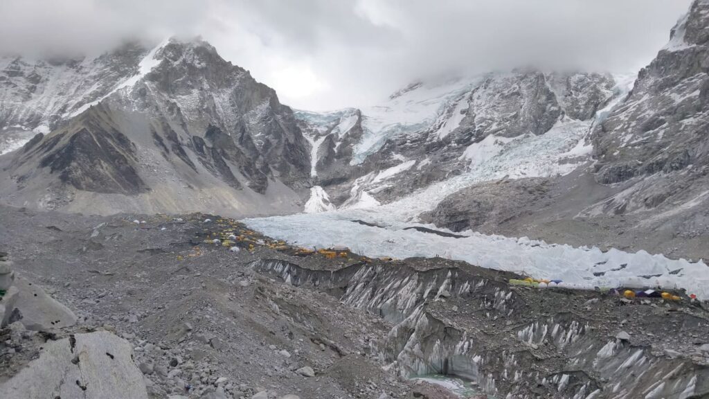
The Icefall Doctors did not sit still. They flew drones over the blockage, ran 3D photogrammetry surveys to map the ice, and tested two alternative routes. Both were ruled out as more dangerous than waiting. So they watched the serac. Checked it daily. After 19 days, the ice shifted enough. They moved fast when it did. Eight aluminium ladders across the worst sections. Drones carrying 50-kilogram supply loads up to Camp I. By evening, the route was fixed to Camp II at around 6,400 metres. Nepal’s Director General of Tourism confirmed it publicly. Open, with a caution flag still flying over the serac section, which has not fully collapsed and remains unstable.
The season is running three weeks behind. The May summit window will be crowded. But it is open, and Base Camp right now has the energy of a place that just exhaled after holding its breath for weeks.
Why Everest Is Safer Now
Dr. Paul Firth led the Harvard study. He is not just an academic. He is a mountaineer who once had to turn his own team around on summit day when his oxygen equipment failed. He knows the difference between what looks safe on paper and what it actually feels like at 8,000 metres.
His research points to a few things that have genuinely changed:
- Fixed ropes now line the entire standard route, fewer falls, fewer climbers getting separated
- Weather forecasting is dramatically better, cutting losses from storms
- Oxygen systems, clothing, nutrition, and communication gear have all improved
- Teams work better together and fewer people are being left behind
What has not changed: most deaths still happen on good-weather days, in the death zone above 8,000 metres, simply because of the cold and the altitude. Improved forecasting means fewer people are caught in storms, so the deaths that remain are the hardest kind to prevent.
For trekkers heading to Base Camp, the direct relevance of this is limited. You are not going anywhere near the death zone. But the point stands: the terrain, the altitude, and the cold demand real respect even on the trekking trail below.
What the Trek Is Actually Like
The route runs 12 to 14 days from Lukla, a small mountain airstrip with a runway that ends at a cliff edge and a reputation that precedes it. From there you walk. Through rhododendron forests, river valleys, suspension bridges strung with prayer flags, yak caravans that have right of way over everything. Teahouses the whole way. No camping required, no technical climbing, no prior mountaineering experience needed.
Namche Bazaar · 3,440m
The first real stop, and most people’s first surprise. Namche Bazaar is a proper town with coffee shops, bakeries, and a Saturday traders’ market that pulls in Tibetans from across the border. You spend two nights here to acclimatise. The ridge above town on a clear morning gives you your first unobstructed view of Everest. Most people stop mid-step when they find it.
Tengboche Monastery · 3,867m
A 400-year-old monastery on a ridge with Ama Dablam’s near-perfect pyramid directly in front and Everest above the ridgeline behind. Arrive before dark. Sit for a while. It is one of those places where you understand, without needing it explained, why people keep coming back to this part of the world.
Kala Patthar · 5,644m
A steep side-peak above Gorak Shep that most people climb at 3am with headlamps. The view from the top
— Everest’s full south face, the Khumbu Glacier, Base Camp below — is better than the view from Base Camp itself. Cold, hard work getting there. Nobody complains at the top.
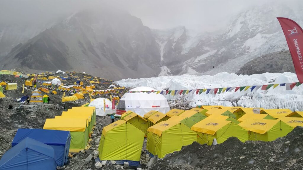
Everest Base Camp · 5,364m
No single dramatic view. No summit beneath your feet. Just a flat, rocky expanse at the edge of the Khumbu Icefall, covered in expedition tents and the sound of shifting ice. Standing there is different to looking at photos of it. Most people cannot fully explain why. You will understand when you get there.
The 14-Day Itinerary
This is the standard route most trekkers follow. Pacing can shift slightly depending on your group and acclimatisation, but the structure below is what works.
Day 1 | Kathmandu
- Arrive, rest, gear check.
- Altitude: 1,400m
Day 2 | Fly to Lukla, Trek to Phakding
- Short first day through pine forests along the Dudh Koshi river.
- Altitude: 2,610m • 3 hrs walk
Day 3 | Phakding to Namche Bazaar
- Crosses several suspension bridges before the long climb up to Namche. First views of Thamserku and Kongde.
- Altitude: 3,440m • 5–6 hrs walk
Day 4 | Acclimatisation Day in Namche
- Rest day. Short hike up to the Everest View Hotel ridge for your first proper look at Everest, Lhotse and Ama Dablam.
- Altitude: 3,440m • Optional 2–3 hrs hike
Day 5 | Namche to Tengboche
- Through rhododendron forest. Tengboche Monastery at golden hour if the timing works out.
- Altitude: 3,867m • 5–6 hrs walk
Day 6 | Tengboche to Dingboche
- Descends into the Imja Valley then climbs out again. The landscape opens up here, above the treeline.
- Altitude: 4,410m • 5 hrs walk
Day 7 | Acclimatisation Day in Dingboche
- Hike up to the ridge above Dingboche for views of Makalu, Lhotse and Ama Dablam. This hike matters for your body.
- Altitude: 4,410m • Optional 3 hrs hike
Day 8 | Dingboche to Lobuche
- The terrain gets starker. Stops at the Thukla Memorial, a ridge of stone cairns honouring climbers who died on Everest.
- Altitude: 4,940m • 5 hrs walk
Day 9 | Lobuche to Gorak Shep, then Base Camp
- Early start. Drop your bags at Gorak Shep, walk to Base Camp in the afternoon while energy is still good.
- Altitude: 5,164m / 5,364m • 7–8 hrs total
Day 10 | Gorak Shep to Kala Patthar, then descend to Pheriche
- 3am start for Kala Patthar sunrise. Then descend all the way to Pheriche. Long day but your legs will be strong by now.
- Altitude: 5,644m / 4,240m • 8–9 hrs
Day 11 | Pheriche to Namche Bazaar
- Fast descent. The body handles downhill well by this point. Back to teahouse comfort and a proper meal.
- Altitude: 3,440m • 6–7 hrs walk
Day 12 | Namche to Lukla
- Last full walking day. Familiar trail, different feeling on the way back.
- Altitude: 2,860m • 6–7 hrs walk
Day 13 | Fly Lukla to Kathmandu
- Weather permitting. Always build a buffer day here in case of delays.
- Altitude: 1,400m
Day 14 | Kathmandu
- Rest, debrief, celebrate.
- Altitude: 1,400m
The Challenges
Altitude
This is the main thing. At Base Camp you are above 5,300 metres, roughly half the oxygen of sea level. Headaches are expected, especially in the first days above Namche. Sleep gets disrupted. Appetite disappears. All of that is normal. What is not normal, and what you have to watch for, is Acute Mountain Sickness getting worse while you are resting. If that happens, you go down. Not tomorrow. Now. A good guide will make this call with you. Do not fight it.
Physical demand
Five to seven hours of walking daily, on rocky uneven trail, at altitude. You do not need to be an athlete, but you need to not be starting from zero. Start hiking with a loaded pack 8 to 12 weeks out. Elevation gain in training matters more than distance.
Cold
Spring is the best season on the mountain and still, nights at Gorak Shep drop well below -10°C. Base Camp at night is genuinely freezing. This is not a situation for a travel fleece and optimism. Pack a proper sleeping bag, real down layers, and waterproof everything.
This season specifically
The serac that caused the blockage is still there, partially collapsed and being monitored. Authorities have warned it could shift further. Climbers heading above Base Camp are advised to move fast through the affected zone and avoid heavy loads. As a trekker, the route to Base Camp itself is not affected, but this is the context on the mountain right now.
| Item | Cost (USD) |
|---|---|
| TIMS Card (permit) | ~$15 |
| Sagarmatha National Park entry | ~$22 |
| Kathmandu to Lukla Flight(return) | ~$200–250 |
| High-altitude rescue insurance | ~$80–120 |
| Budget guided trek (12–14 days) | from ~$800–1,200 |
| Standard package (teahouses, meals, guide, porter, permits) | ~$1,200–1,800 |
| Private or custom trek | ~$2,000–3,000+ |
| Meals on trail (per meal) | $5–15 |
| Guide tip (per day) | $12–18 |
| Porter tip (per day) | $8–12 |
| Gear rental in Thamel, Kathmandu | ~$50–150 |
Realistic total: $1,500 to $2,500 USD, not including your international flights to Nepal.
At a Glance
Best seasons Spring (Apr–May) · Autumn (Oct–Nov)
| Trek duration | 12–14 days from Lukla |
| Highest point | 5,644m Kala Patthar · 5,364m Base Camp |
| Technical skill | None required |
| Fitness level | Moderate, long daily walking at altitude |
| Health prep | Travel doctor consult · Carry Diamox · Hep A + Typhoid |
| Connectivity | Mobile signal to Pheriche · WiFi at most teahouses |
Trek With Create Himalayan Adventure
We have been guiding the Khumbu for years. Not the guidebook version, the version where you know which teahouse has the best dal bhat above Namche, where to stand on the Tengboche ridge to get Ama Dablam without the power lines in frame, and what pace actually gets you to Base Camp feeling strong instead of wrecked.
Small groups, licensed guides, full local support, proper acclimatisation built into every itinerary. We also run treks to Annapurna, Langtang, Upper Mustang, and Dolpo for those who want to go somewhere the crowds have not completely found yet.
If you are thinking about this, get in touch. We will tell you honestly whether you are ready and help you plan it right.
Ramchandra Lamichhane
Trekking Expert
No hidden fees • Local experts • Best price guarantee