
Massive Flood in Nepal 2026: Causes, Destruction, Affected Areas and Safety Guide
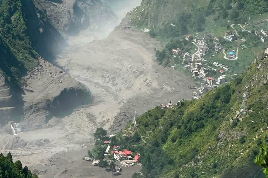
Nepal is experiencing a devastating flash-flood disaster in the Himalayan region, with the most serious destruction concentrated around Rasuwa and the Bhotekoshi–Lhende river corridor. The event has destroyed homes, roads, bridges, vehicles and other essential infrastructure, while hundreds of people have been reported dead, missing or unreachable. The disaster has also disrupted transportation and communication in several mountain communities, making rescue and recovery particularly difficult.
Unlike a typical monsoon flood that develops gradually after prolonged rainfall, this event happened with extraordinary speed. A sudden movement of rock, mud, ice and water in the high Himalayan region created a powerful surge that travelled downstream through narrow valleys. Communities located close to the river had very little time to respond. The combination of steep Himalayan terrain, unstable slopes, swollen rivers and infrastructure built along river corridors has made the consequences especially severe.
Because rescue operations and damage assessments are still continuing, casualty and infrastructure figures should be treated as preliminary. Numbers reported by authorities and international media may change as missing people are located and previously inaccessible areas become reachable.
How Did the Massive Flood in Nepal Start?
The exact chain of events behind the flood is still being investigated, but preliminary reports indicate that the disaster began in the high Himalayan region near the Nepal–China border. An earthquake was recorded in the area, and authorities have been examining whether the seismic activity contributed to a landslide, avalanche or large debris movement that entered the river system.
The significance of this possible trigger is that a sudden collapse of material into a mountain river can displace a huge amount of water in a very short period. The resulting flood does not behave like ordinary rainfall runoff. Instead, it can carry boulders, soil, trees, ice and broken infrastructure downstream with enormous force. This mixture becomes a destructive debris flow capable of tearing through buildings and bridges.
The flood subsequently travelled toward Nepal’s Rasuwa district, following the natural course of the river system. Once the water and debris reached narrower valleys, its destructive energy became even greater. Villages, roads, bridges, hydropower facilities and businesses located close to the river were exposed directly to the surge.
It is therefore more accurate to describe the incident as a sudden Himalayan flash flood and debris-flow disaster, rather than simply saying that heavy monsoon rain caused the entire event.
Why Did the Flood Become So Destructive?
Several geographical and environmental conditions combined to make this disaster exceptionally dangerous. Himalayan rivers often run through steep valleys where there is limited space between the river and surrounding mountains. When an extraordinary amount of water suddenly enters such a river, the flood can move downstream at tremendous speed.
The flood was also filled with sediment and large debris. Water mixed with rocks, mud and trees can exert much greater destructive pressure than clear water. It can block roads, smash bridges, bury buildings and change the course of smaller streams.
Another factor is the location of human settlements and infrastructure. Mountain roads, hydropower projects, commercial buildings and residential areas frequently follow river valleys because these are the most practical routes through difficult terrain. That means the same corridors that provide transportation and economic opportunities can also become highly exposed during major floods.
The disaster was further complicated by damaged roads and bridges. Once transportation links were severed, rescue teams faced significant difficulties reaching isolated communities. Emergency response in the mountains is naturally slower than in accessible urban areas, and damaged infrastructure makes the process even more challenging.
Rasuwa: The Main Centre of the Disaster
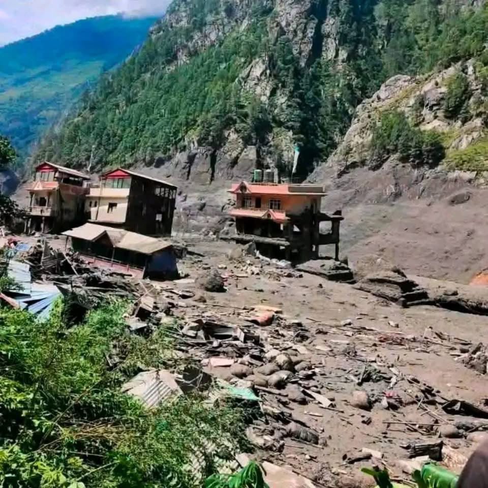
Rasuwa has experienced the most severe impact of the flood. The district is strategically important because it connects Nepal with Tibet through the Rasuwagadhi border area. It also contains settlements, highways, hydropower projects and commercial facilities along narrow river valleys.
Areas around Timure, Syaphrubesi and Rasuwagadhi have been particularly affected. Floodwater and debris damaged structures close to the river and disrupted the road network connecting the border region with the rest of Nepal.
The damage in Rasuwa is not only a local humanitarian crisis. The area is an important transportation and trade corridor, so the destruction of roads and bridges has implications for the movement of people and goods between Nepal and China.
For local residents, however, the immediate concern is much more personal: finding missing family members, securing safe accommodation, obtaining food and clean water, and restoring communication.
Nuwakot Also Suffers Major Flood Damage
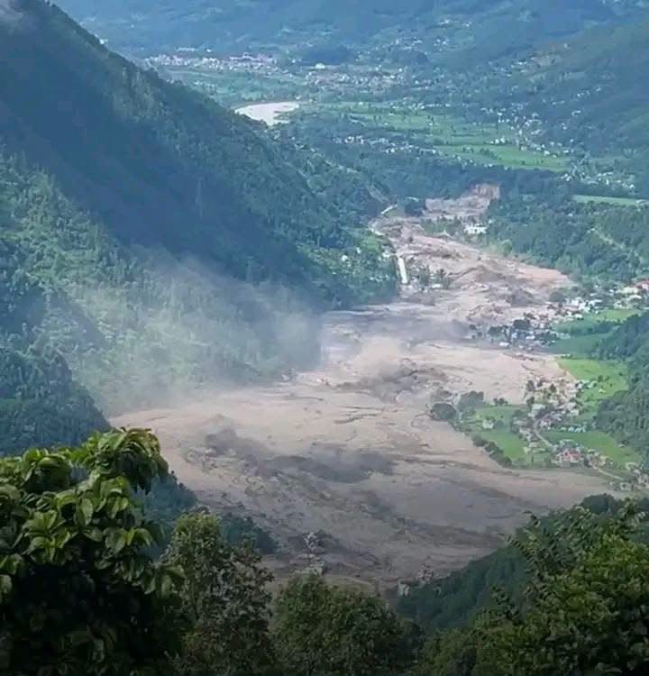
The flood moved downstream from the Himalayan border region and affected Nuwakot, where communities along the Trishuli and connected waterways experienced serious consequences.
Several riverside settlements have reported damaged homes, roads and other structures. The force of the water also affected transportation infrastructure, making movement between communities difficult.
Nuwakot is geographically closer to the Kathmandu Valley than Rasuwa, which makes the situation particularly important for travellers and residents who normally use these roads to reach northern districts.
The damage demonstrates how a disaster that starts in a remote Himalayan valley can rapidly affect areas much farther downstream.
Other Districts Facing River and Flood Risks
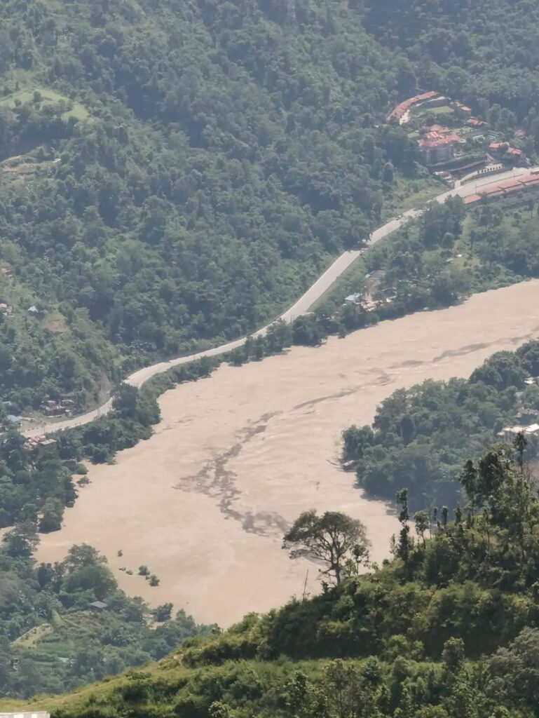
The effects and warnings have extended beyond the two most heavily affected districts. Dhading, Gorkha and Chitwan are among the areas where people living near rivers have been advised to remain alert.
This does not mean that every municipality or settlement within these districts has suffered the same level of destruction. The risk is largely associated with rivers, low-lying areas and locations vulnerable to sudden changes in water levels.
People should therefore avoid assuming that a location is safe simply because it is several kilometres away from the original flood source. Mountain rivers connect distant communities, and water levels can rise rapidly following an upstream event.
How Many People Have Been Killed?
The number of casualties is still developing. Early reports provided much lower figures because rescue teams were initially unable to reach some affected locations. As access improved, more victims were recovered and the reported death toll increased.
International reports have placed the number of deaths in Nepal at around 95 or more, while additional casualties have been reported across the border in China. Hundreds of people have also been reported missing or unaccounted for.
These figures should not be considered the final toll. In a disaster involving remote mountain settlements, it can take considerable time to establish the condition of every household and identify people who may have been travelling through the region.
It is also important to distinguish between missing, unreachable and confirmed dead. A person who cannot be contacted may be safe but unable to communicate because electricity, telephone networks and roads have been disrupted.
Hundreds of People Remain Missing or Unreachable
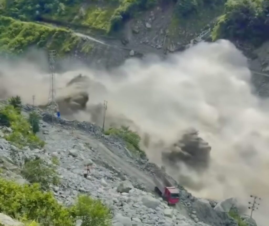
One of the most concerning aspects of the disaster is the number of people whose whereabouts remain uncertain.
The affected region is used by local residents, workers, traders, tourists, pilgrims and people travelling toward the Nepal–China border. During periods of high travel activity, it can be particularly difficult to determine exactly who was present in a particular settlement or workplace when the flood occurred.
Foreign nationals have also been reported among those who lost contact with their families or authorities. Governments and embassies have been working to identify their citizens and determine whether they are safe.
Search-and-rescue teams therefore face two simultaneous challenges: physically finding people in damaged areas and establishing accurate lists of those who may be missing.
How Many Houses Were Destroyed?
A final official number of completely destroyed houses is not yet available. This is because some locations remain difficult to access and authorities must conduct detailed assessments before distinguishing between completely destroyed, partially damaged and temporarily uninhabitable properties.
Nevertheless, the available reports and visual evidence demonstrate substantial residential destruction. Some homes near rivers have been swept away, while others have suffered structural damage from floodwater, rocks and debris.
For affected families, even a partially damaged house can become a major humanitarian problem. Floodwater can destroy furniture, food supplies, clothing, documents, electrical equipment and other essential possessions. Walls and foundations can also become unstable after prolonged exposure to water.
The final housing assessment will therefore need to consider not only houses that disappeared completely, but also properties that require major reconstruction before families can safely return.
Roads and Bridges Face Severe Destruction
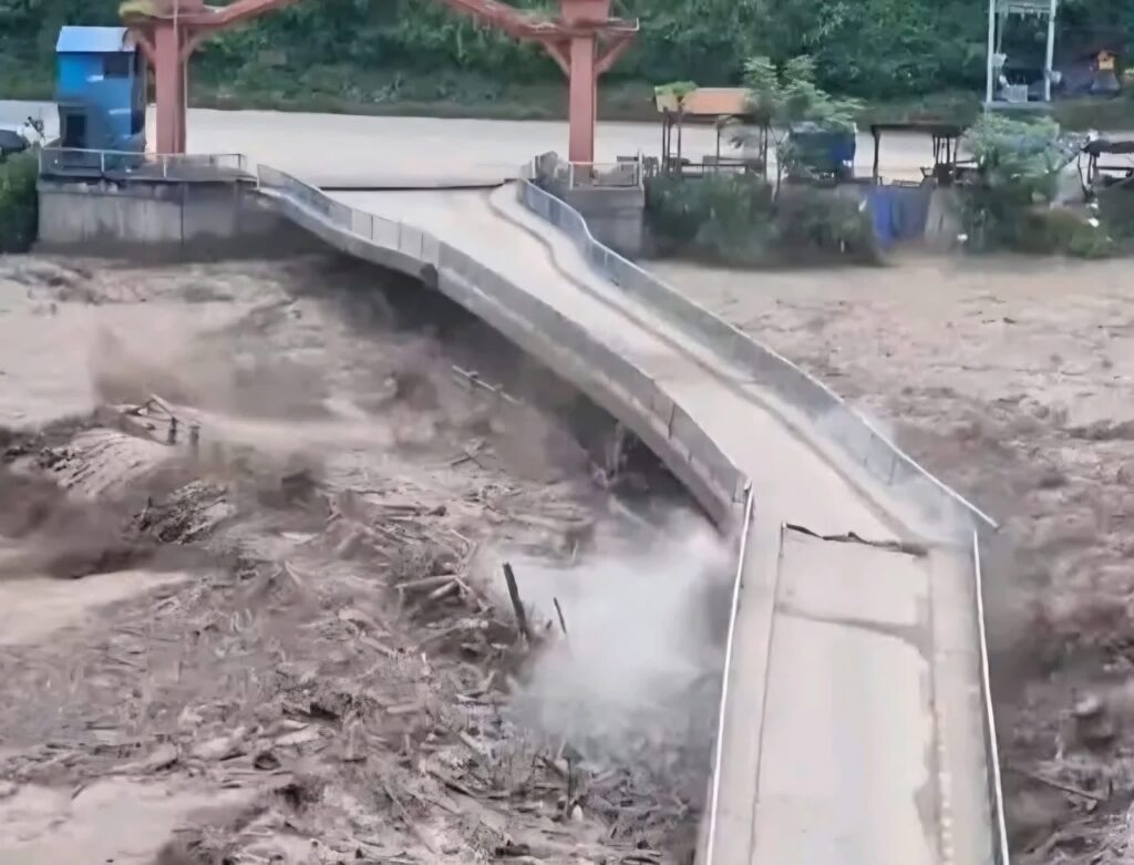
Transportation infrastructure has been among the most visible victims of the disaster.
The road connection between Betrawati and Rasuwagadhi has suffered extensive damage, with large sections affected by the flood. Bridges have also been washed away or weakened, leaving communities isolated.
A damaged mountain road is particularly serious because there are often few alternative routes. In urban areas, traffic can usually be redirected through another street. In the Himalayas, however, one bridge or road may be the only practical connection between several settlements.
The destruction therefore affects more than transportation. It can delay the delivery of medicine, food, drinking water and rescue equipment. It can also prevent residents from reaching hospitals, markets and government services.
Rebuilding these routes may require months or longer depending on the extent of erosion, bridge damage and slope instability.
Hydropower Infrastructure Has Also Been Affected
Nepal’s hydropower infrastructure has suffered significant damage in the affected region. Several projects in Rasuwa and Nuwakot have been impacted by the flood, including facilities that were operating and projects still under development.
Hydropower stations are often located beside rivers because they depend on water resources for electricity generation. This makes them economically valuable but also exposes them to extreme river events.
Damage to hydropower facilities can create long-term financial consequences. Equipment may require replacement, access roads may need reconstruction and generation can remain suspended until engineers confirm that facilities are safe.
The reported impact on hundreds of megawatts of generation capacity demonstrates that the disaster is not simply a short-term transportation emergency. It has also affected Nepal’s energy infrastructure.
Damage to Electricity and Communication
Electricity and communication services are essential during any disaster. When power lines, substations, telecommunications equipment or access roads are damaged, emergency coordination becomes much harder.
Families may be unable to contact relatives. Rescue teams may have difficulty receiving information from isolated settlements. Businesses cannot operate normally, and health facilities may need alternative power sources.
For this reason, restoring communication networks is an important part of disaster response. Authorities and service providers need to establish temporary systems where permanent infrastructure has been damaged.
Is Nepal Safe Right Now?
The answer depends strongly on where in Nepal you are travelling.
It would be incorrect to say that the entire country is unsafe because of the Rasuwa flood. Nepal is a large country, and the severity of the current disaster is concentrated around particular river corridors.
However, the Rasuwa–Bhotekoshi–Rasuwagadhi area should be treated as a high-risk zone while rescue operations and infrastructure assessments continue.
Travellers should not enter severely affected settlements simply to see the damage. Disaster areas are not tourist attractions, and unnecessary visitors can interfere with rescue operations.
People planning travel toward northern Rasuwa should wait for reliable information regarding road access, bridge conditions and local security before proceeding.
Could There Be Another Flood or Landslide?
Yes. The danger may continue even after the first major flood wave has passed.
Mountain slopes can remain unstable after a landslide or earthquake. Heavy monsoon rainfall can further weaken exposed ground. Flood debris can temporarily block a river, creating a natural dam. If that blockage suddenly collapses, another surge of water may move downstream.
For these reasons, people should not assume that a calm river means the danger has completely disappeared.
Communities should remain particularly careful during rainfall and should respond immediately to official warnings about unusual river levels or possible secondary hazards.
How Can People Stay Safe During the Current Situation?
The most effective protection is early movement away from dangerous river corridors. People should never wait until floodwater reaches their doorstep before deciding where to go.
If authorities issue an evacuation order, residents should leave immediately and take essential documents, medicines, drinking water, basic clothing and communication devices if it is safe to do so.
People should avoid riverbanks, bridges and low-lying areas during periods of heavy rain. A river that appears manageable can rise extremely quickly after an upstream event.
Flooded roads should never be crossed on foot, motorcycle or vehicle unless emergency authorities have confirmed that the route is safe. Water can conceal missing sections of road, deep holes and collapsed edges.
People should also stay away from damaged buildings. Floodwater can weaken foundations and walls, creating a risk of sudden collapse even after the water has receded.
Do Not Believe Every Social-Media Update
During major disasters, information spreads quickly. Unfortunately, not every photograph, video or casualty figure shared online is accurate.
Old flood photographs can be presented as current events, while unverified posts may exaggerate casualty numbers or incorrectly identify affected locations.
People should obtain important information from government authorities, local administrations, police, emergency agencies, established news organizations and recognized humanitarian organizations.
Families searching for missing people should also provide accurate information to authorities rather than sharing unconfirmed claims publicly.
Reliable information is especially important during a disaster because incorrect reports can create panic and make rescue work more difficult.
What Should Tourists and Trekking Travellers Do?
Visitors already in Nepal should remain calm and check the conditions of their specific destination rather than cancelling every travel plan automatically.
However, anyone planning to travel toward Rasuwa, Rasuwagadhi or severely affected northern river corridors should postpone the journey until authorities and local transportation operators confirm that access is safe.
Trekking agencies should check weather forecasts, road conditions, local government notices and trail information before moving clients into remote areas.
Travellers should also maintain emergency contacts and make sure someone outside the travelling group knows their itinerary.
For remote mountain travel, flexibility is essential. A road or trail that was open yesterday may become inaccessible after heavy rain or a landslide.
Health and Sanitation After Flooding
The risks continue after floodwater disappears.
Floods can contaminate drinking-water sources with sewage, mud, chemicals and other pollutants. Damaged sanitation systems can increase the risk of disease, while standing water can create additional public-health concerns.
People should use safe drinking water and avoid consuming food that has been contaminated by floodwater. Injuries caused by broken glass, metal, rocks and debris should be cleaned and treated promptly.
Electrical equipment and power lines should also be treated as dangerous until professionals confirm that they are safe.
Medical teams and local authorities have an important role in monitoring health conditions in temporary shelters and affected communities.
Why Early-Warning Systems Matter in Nepal
The disaster highlights a major challenge for Nepal: communities in mountainous areas need warnings that reach them before a dangerous river surge arrives.
Technology can play an important role. River-level sensors, rainfall monitoring, seismic information, satellite observation and community-based warning networks can help authorities identify dangerous conditions.
But technology alone is not enough. A warning must reach people quickly, and communities need to know exactly what action to take after receiving it.
Local disaster-preparedness training can save lives because residents who understand evacuation routes and safe areas can react more quickly during an emergency.
Building Stronger Infrastructure for the Future
The flood also raises questions about how roads, bridges, hydropower projects and settlements are planned in high-risk mountain environments.
Infrastructure cannot always avoid rivers because geography limits available routes. However, stronger engineering standards, improved riverbank protection, better bridge design and hazard mapping can reduce future losses.
Development in vulnerable flood corridors should be guided by accurate geological and hydrological assessments. Building close to a river may provide convenient access today but create significant risks during an extreme event.
Nepal’s future infrastructure planning therefore needs to balance economic development with long-term disaster resilience.
The Human Story Behind the Disaster
Behind every casualty figure is a family, and behind every destroyed building is someone’s home, workplace or livelihood.
For mountain communities, the loss of a bridge can isolate an entire settlement. The destruction of a road can prevent farmers from reaching markets. Damage to a hydropower project can affect workers and local businesses. The loss of a house can force a family into temporary shelter just before the monsoon season.
Recovery will therefore require more than rebuilding physical structures.
Affected families may need food, shelter, medical assistance, psychological support, financial assistance and help replacing important documents and household possessions.
Nepal Will Need Time to Recover
The immediate priority is saving lives and finding missing people. Once emergency rescue operations are completed, the country will face a second phase: recovery and reconstruction.
Authorities will need to inspect roads and bridges, restore electricity and communications, assess houses, clear debris, reopen transportation corridors and support displaced families.
The reconstruction process should also learn from the disaster. Infrastructure that is rebuilt should ideally be stronger and better adapted to future flood and landslide risks.
Final Conclusion
The August 26, 2026, massive flood in Nepal is a tragic reminder of the extraordinary power of Himalayan rivers and the vulnerability of communities living in steep mountain valleys.
The disaster appears to have begun near the Nepal–China border after a sudden geological event triggered a major movement of rock, mud, ice or debris into the river system. The resulting surge travelled rapidly toward Nepal, causing catastrophic destruction in Rasuwa before affecting downstream areas including Nuwakot and creating warnings for communities in Dhading, Gorkha and Chitwan.
Homes have been destroyed, roads and bridges have been washed away, hydropower facilities have been damaged and communication networks have been disrupted. The human cost is even greater, with a rapidly changing death toll and hundreds of people reported missing or unreachable.
For residents, the message is clear: stay away from swollen rivers, damaged bridges, unstable slopes and flood-affected settlements; follow official warnings; and move to higher ground immediately when instructed.
For tourists, Nepal should not be viewed as uniformly unsafe. The danger is concentrated in particular areas, but travel plans involving Rasuwa and the Nepal–China border corridor should be reconsidered until authorities confirm safe access.
Most importantly, this disaster should remind Nepal and the international trekking community that Himalayan travel requires respect for weather, geology and natural hazards. Preparation, accurate information, early warnings and responsible decision-making can make the difference between a difficult situation and a tragedy.
Nepal has faced many natural disasters before, and its communities have repeatedly demonstrated remarkable resilience. The immediate task is to protect lives, locate missing people, support affected families and restore essential services. The longer-term task is to rebuild more safely and strengthen Nepal’s ability to respond when the next extreme Himalayan event arrives.
Frequently Asked Questions About the Massive Flood in Nepal 2026
1. What happened in Nepal on August 26, 2026?
Nepal experienced a devastating flash-flood and debris-flow event on August 26, 2026, mainly affecting the Himalayan border region of Rasuwa. A sudden surge of water and debris travelled through the Lhende–Bhotekoshi river system, destroying homes, bridges, roads, vehicles and other infrastructure. The disaster also affected downstream communities, particularly in Nuwakot, while authorities issued warnings for several other river-connected districts.
2. Where did the massive Nepal flood begin?
The initial event is believed to have occurred in the high Himalayan region near the Nepal–China border, with reports indicating that a geological disturbance caused a large amount of rock, mud, ice or debris to enter the river system. The exact sequence of events is still being investigated, so the cause should be described as preliminary rather than completely confirmed.
3. Was the Nepal flood caused by heavy rainfall?
Heavy monsoon conditions can increase flood and landslide risks, but this particular disaster appears to have involved a sudden geological event rather than ordinary rainfall alone. Reports indicate that an earthquake may have contributed to a landslide, avalanche or debris movement that suddenly displaced water and generated a powerful flood downstream.
4. Which district was hit hardest by the flood?
Rasuwa was the worst-affected district. Areas around Timure, Syaphrubesi and Rasuwagadhi experienced extensive destruction because they lie close to the affected river corridor. Nuwakot also suffered serious downstream impacts, while authorities monitored river conditions in other districts.
5. Which other districts are at risk from the flood?
Besides Rasuwa and Nuwakot, authorities have warned communities in parts of Dhading, Gorkha and Chitwan to remain alert because of downstream river conditions. The level of damage varies considerably between locations, so an entire district should not automatically be considered equally affected.
6. How many people have died in the 2026 Nepal flood?
The death toll has changed rapidly as rescue workers have reached previously inaccessible areas. International reports have placed the number of deaths in Nepal at around 95 or more, but this should not yet be considered the final figure. Authorities are continuing identification, rescue and recovery operations.
7. How many people are missing after the Nepal flood?
Hundreds of people have been reported missing or unreachable. Some are believed to have been travelling through the border region, while others were residents or workers in affected communities. Because electricity, roads and mobile communication have been disrupted, being unreachable does not necessarily mean that someone has died.
8. Were foreign tourists affected by the Nepal flood?
Yes. Foreign nationals were among those reported missing or temporarily unreachable following the disaster. The affected border corridor is used by tourists, pilgrims, workers and traders, making it difficult initially to establish the whereabouts of everyone in the area. Governments and diplomatic missions have been assisting with efforts to locate their citizens.
9. How many houses were destroyed by the flood?
A definitive number of completely destroyed houses has not yet been established. Many homes have reportedly been swept away or seriously damaged, particularly near rivers in Rasuwa and Nuwakot. A complete assessment requires authorities and engineers to inspect individual settlements and distinguish between completely destroyed, partially damaged and unsafe properties.
10. How much infrastructure was damaged by the Nepal flood?
The destruction has been extensive. Roads and bridges were washed away or badly damaged, while hydropower projects, electricity facilities, commercial buildings and border infrastructure were also affected. The damage to transportation is especially serious because some mountain communities depend on a single road or bridge for access to markets, hospitals and emergency services.
11. Was the Rasuwagadhi border crossing affected?
Yes. The area around Rasuwagadhi, an important Nepal–China border point, experienced severe flooding and infrastructure damage. Roads and facilities in the surrounding corridor were affected, disrupting normal movement and making the area unsuitable for unnecessary travel while emergency operations continue.
12. Is Rasuwa safe for tourists right now?
Travelling into severely affected parts of Rasuwa is not advisable while rescue operations, road assessments and recovery work are underway. Timure, Rasuwagadhi, Syaphrubesi and nearby riverside areas should be approached only when local authorities confirm that access is safe. Travellers should not enter disaster zones simply to observe the damage.
13. Is the whole of Nepal unsafe because of the flood?
No. The disaster is not affecting every part of Nepal equally. The most serious danger is concentrated around specific river corridors and affected mountain districts. Travellers elsewhere in Nepal should still monitor weather and road conditions, particularly during the monsoon, but the Rasuwa disaster should not be interpreted as meaning that the entire country is closed or unsafe.
14. Can another flash flood happen after the first flood?
Yes, another flood or secondary disaster is possible. Heavy rainfall, unstable slopes, landslides and temporary blockages created by rocks and debris can alter river levels suddenly. People living near affected rivers should therefore remain cautious even after the initial floodwater has receded.
15. Why are people being told to stay away from rivers after the flood?
Flooded rivers can remain dangerous long after the main surge has passed. Riverbanks may have been weakened, bridges may have hidden structural damage and debris can change the river’s flow. Another upstream landslide or sudden release of water can also cause an unexpected rise in river levels.
16. What should people do if the river suddenly rises?
People should move immediately to higher and safer ground rather than waiting to see whether the water reaches their homes. Important documents, medicines, drinking water and communication devices can be taken if they are readily accessible, but personal belongings should never delay evacuation.
17. Is it safe to cross a flooded road by car or motorcycle?
No. Even shallow-looking floodwater can conceal a collapsed road surface, deep erosion or strong currents. Vehicles can lose control or be swept away. A road that appears intact from a distance may have been undermined beneath the water, making it extremely dangerous to cross.
18. Should people return to homes after the floodwater goes down?
They should return only after local authorities or qualified officials confirm that the area is safe. Floodwater can weaken foundations, walls, electrical systems and nearby slopes. Buildings that survived the initial flood may still collapse later, particularly if their foundations have been undermined.
19. How can travellers stay informed during the Nepal flood situation?
Travellers should rely on official government announcements, local authorities, police, emergency services and reputable news organizations. They should also check road conditions with their accommodation provider, guide or trekking agency before travelling into remote areas. Unverified social-media posts should not be treated as reliable emergency information.
20. What should trekking and tour companies do during a flood emergency?
Trekking and tour companies should prioritize client safety over completing an itinerary. They should check weather, river and road conditions, maintain contact with guides and local authorities, keep accurate traveller records and change or postpone routes when conditions become dangerous. A responsible operator should never take clients into an area that authorities have identified as unsafe.
21. What health problems can occur after a major flood?
The danger continues after the water disappears. Flooding can contaminate drinking water, damage sanitation systems and leave behind sharp debris, chemicals and unstable structures. People may also face injuries, unsafe electrical equipment and poor conditions in temporary shelters. Safe drinking water, hygiene, medical care and careful inspection of damaged buildings are essential during recovery.
22. Why is communication difficult after a Himalayan flood?
Floods can destroy electricity lines, mobile towers, fibre-optic connections, roads and bridges at the same time. Mountain geography can make alternative communication particularly difficult. As a result, families may temporarily lose contact with people who are actually safe, which is one reason official missing-person verification can take time.
23. Could the flood affect trekking routes elsewhere in Nepal?
It can affect particular routes indirectly through road closures, landslides, damaged bridges and transportation disruptions, but the impact depends on the destination. Trekkers should check the specific trail and transportation route rather than assuming that every trekking region has been affected. Conditions can change quickly during the monsoon season.
24. What is the biggest lesson from the Nepal flood?
The disaster demonstrates the importance of early warnings, safe settlement planning, resilient infrastructure and rapid evacuation procedures in Himalayan communities. Nepal’s mountainous environment is naturally exposed to landslides, flash floods, earthquakes and extreme rainfall. Better monitoring and faster communication can give communities more time to move away from danger.
25. How long will Nepal need to recover from the flood?
Recovery will take much longer than the initial rescue operation. Clearing debris may restore some roads relatively quickly, but rebuilding destroyed bridges, houses, hydropower facilities and major road sections can take months or even years. A proper recovery will also require financial assistance, livelihood support and stronger infrastructure designed to withstand future disasters.
26. Is it safe to travel to Nepal after the August 2026 flood?
Nepal should not be considered completely unsafe because of this single disaster. Many destinations remain outside the directly affected flood corridor. However, travellers should carefully check their intended route, particularly if travelling toward Rasuwa, the Nepal–China border or other flood-affected river valleys. Flexibility is important because monsoon weather can cause new landslides and road closures.
27. What is the safest place to stay during a flash flood?
The safest option is generally higher ground away from rivers, flood channels, unstable slopes and damaged structures. The exact evacuation location depends on the local geography, so residents should follow designated evacuation instructions from local authorities rather than choosing a location based only on distance from the river.
28. Why should people avoid sharing unverified casualty figures?
During an evolving disaster, casualty numbers can change rapidly. Incorrect figures can cause unnecessary panic, distress families searching for relatives and make emergency communication more difficult. It is better to identify figures as preliminary and provide the date and source of the information.
29. What should families do if they cannot contact someone in the affected area?
Families should avoid immediately assuming the worst. They should contact the person’s travel company, accommodation provider, workplace, local authorities, police or relevant embassy where appropriate. They should provide accurate identifying information and avoid spreading unverified reports until authorities confirm the person’s status.
30. What is the most important safety advice for people living near affected rivers?
The most important advice is to take official warnings seriously and leave riverbanks early when authorities advise evacuation. Do not wait for visible floodwater, do not cross damaged bridges, do not drive through flooded roads and do not return to an evacuated area until officials confirm that it is safe. In a sudden Himalayan flash flood, early action can save lives.
Ramchandra Lamichhane
Trekking Expert
No hidden fees • Local experts • Best price guarantee