
Kailash Mansarovar Overland Tour via Kodari–Zhangmu–Nyalam Route
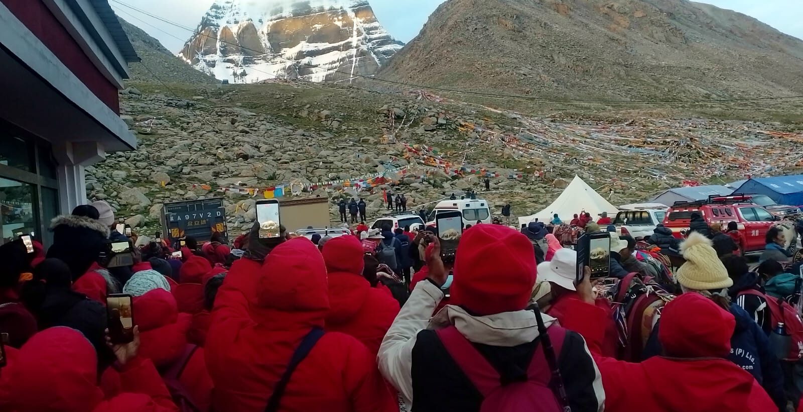
Introduction
The Kailash Mansarovar Overland Tour via Kodari–Zhangmu–Nyalam follows one of the oldest and most memorable land routes between Nepal and Tibet. For decades, pilgrims traveling from Kathmandu toward Mount Kailash and Lake Mansarovar used the Kodari border before continuing through Zhangmu and Nyalam into the Tibetan Plateau.
The route has a remarkable history. The 2015 Nepal earthquake caused extensive damage across the Kodari–Tatopani area, and the traditional Nepal–Tibet crossing was subsequently closed for an extended period. As travel through the northern border gradually changed, the Rasuwagadhi–Kerung (Gyirong) corridor became the principal gateway for many Kailash Mansarovar journeys from Nepal.
The border situation changed again in 2026. A devastating flash flood in the Rasuwa region on August 26, 2026, severely damaged infrastructure around Rasuwagadhi and disrupted the Kerung border corridor. The disaster has created major challenges for cross-border travel and has made the condition of Nepal’s northern gateways an important consideration for future Kailash pilgrims.
The Kodari–Zhangmu route should therefore be viewed as a potential alternative rather than a currently guaranteed operating route. The Tatopani/Kodari crossing has also experienced temporary closure because of landslide risks, meaning that travelers must receive official confirmation before making arrangements.
Once the border is officially reopened and authorized for pilgrimage travel, the Kodari route offers a fascinating alternative approach to Tibet. From Kathmandu, the journey climbs through the green hills of Nepal, crosses the historic frontier at Kodari, reaches Zhangmu and Nyalam, and eventually enters the immense Tibetan Plateau. From there, the pilgrimage continues toward Saga, Lake Mansarovar, Darchen and the sacred Mount Kailash Kora.
This journey combines road travel, high-altitude landscapes and one of the world’s most revered pilgrimages. It is not merely a transportation route; it is a gradual transition from the valleys of Nepal into the spiritual and starkly beautiful landscape of western Tibet.
Travel Notice: The Kodari–Zhangmu–Nyalam itinerary is subject to Chinese and Nepalese border regulations, road conditions, permits, weather and official authorization. Travelers should confirm the current border status before booking flights or making non-refundable travel arrangements.
Kailash Mansarovar Overland Tour via Kodari at a Glance
| Travel Information | Details |
|---|---|
| Route | Kathmandu – Kodari – Zhangmu – Nyalam – Saga – Mansarovar – Darchen – Kailash Kora |
| Starting Point | Kathmandu, Nepal |
| Border Crossing | Kodari–Zhangmu |
| Main Acclimatization Stop | Nyalam |
| Lake Mansarovar Elevation | Approx. 4,590 m |
| Darchen Elevation | Approx. 4,670 m |
| Dolma La Pass | Approx. 5,630 m |
| Kailash Parikrama | Approx. 52 km |
| Kora Duration | 3 days |
| Overall Duration | Approximately 14 days |
| Highest Point | Dolma La Pass |
| Tour Style | Overland pilgrimage |
| Difficulty | Moderate to challenging |
| Main Challenge | High altitude and long travel days |
Distances and driving times are approximate and may change according to road conditions, border procedures, local regulations and the approved Tibet travel route.
Day-by-Day Kailash Mansarovar Overland Itinerary
Day 01: Arrival in Kathmandu
- Altitude: 1,350 m / 4,430 ft
- Driving: Airport to hotel
- Overnight: Kathmandu
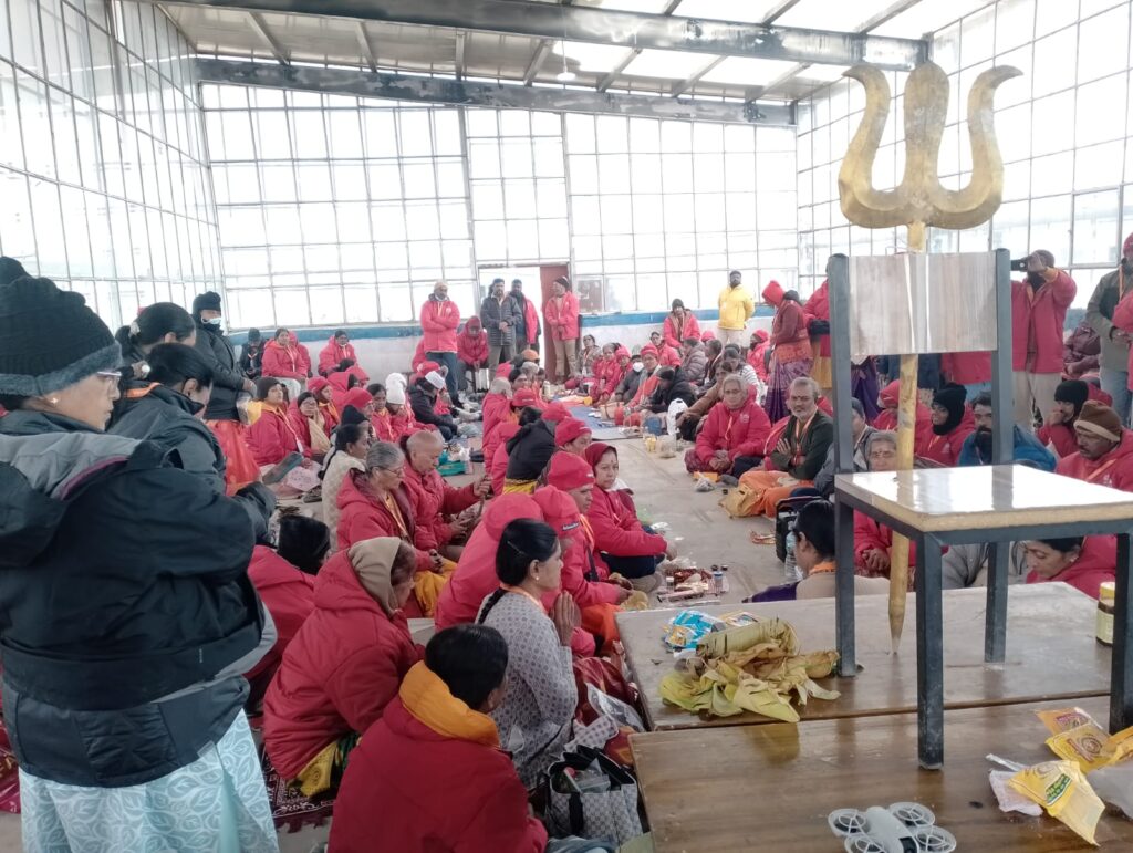
Welcome to Kathmandu, the starting point of your Kailash Mansarovar pilgrimage. After arriving at Tribhuvan International Airport, our representative will meet you and transfer you to your hotel.
The remaining time is used for rest and final preparation. Your guide will provide a detailed briefing about the Tibet journey, border procedures, high-altitude travel and the Mount Kailash Parikrama.
Highlights: Arrival, pilgrimage briefing and final preparation.
Day 02: Kathmandu – Kodari – Zhangmu – Nyalam
- Altitude: Kathmandu 1,350 m → Kodari 1,750 m → Zhangmu 2,300 m → Nyalam 3,750 m
- Distance: Approx. 125–145 km
- Driving: Approx. 6–9 hours, excluding border formalities
- Overnight: Nyalam
After breakfast, drive east from Kathmandu along the historic Arniko Highway toward Kodari.
The road passes through Nepal’s hilly countryside before reaching the traditional Nepal–Tibet frontier. After completing the required immigration and border procedures, continue into Tibet through Zhangmu.
From Zhangmu, the road climbs rapidly toward Nyalam. The change in elevation is significant, so the evening is reserved for rest and gentle acclimatization.
Highlights: Arniko Highway, Kodari border, Zhangmu and Himalayan mountain scenery.
Day 03: Acclimatization in Nyalam
- Altitude: 3,750 m / 12,300 ft
- Walking: Approx. 3–6 km, optional
- Overnight: Nyalam
Today is an important acclimatization day in Nyalam.
Instead of traveling onward immediately, you will have time to allow your body to adjust to the increasing altitude. A short and easy walk around the local area may be arranged according to weather and group conditions.
Keep yourself hydrated, eat well and avoid unnecessary physical exertion. Your guide will monitor everyone’s condition before the journey continues toward the higher Tibetan Plateau.
Highlights: Acclimatization, mountain views and preparation for high-altitude travel.
Day 04: Nyalam – Acclimatization and Preparation
- Altitude: 3,750 m / 12,300 ft
- Walking: Easy local walk
- Overnight: Nyalam
A second night in Nyalam provides additional time for altitude adjustment.
The day remains relaxed. You may take a gentle walk if you are feeling well, while the remainder of the day can be spent resting and organizing your personal belongings for the long overland journey ahead.
This extra acclimatization day is particularly valuable because the route beyond Nyalam gradually moves above 4,000 meters.
Highlights: Rest, acclimatization and final preparation for the Tibetan Plateau.
Day 05: Nyalam – Saga
- Altitude: Nyalam 3,750 m → Saga approx. 4,600 m
- Distance: Approx. 250–260 km
- Driving: Approx. 7–9 hours
- Overnight: Saga
Leave Nyalam after breakfast and continue westward toward Saga.
The landscape changes as the road leaves the narrow Himalayan valleys and enters the enormous Tibetan Plateau. Dry mountains, wide valleys and open high-altitude plains gradually replace the greener scenery of Nepal.
Saga is an important stop on the route to Mount Kailash and Lake Mansarovar. Because the overnight altitude is already above 4,500 meters, take the evening slowly and allow your body to recover from the day’s drive.
Highlights: Tibetan Plateau, vast landscapes and high-altitude scenery.
Day 06: Saga – Lake Mansarovar
- Altitude: Saga approx. 4,600 m → Lake Mansarovar approx. 4,590 m
- Distance: Approx. 450–500 km
- Driving: Approx. 8–10 hours
- Overnight: Mansarovar area
Today you travel deeper into western Tibet toward one of the principal spiritual destinations of the pilgrimage: Lake Mansarovar.
The long drive crosses an extraordinary high-altitude wilderness of barren mountains, open plains and distant snow-covered peaks. As you approach the lake, the landscape becomes increasingly sacred and dramatic.
The first sight of the turquoise waters of Mansarovar, surrounded by the immense Tibetan landscape, is a memorable moment for pilgrims.
Highlights: Tibetan Plateau, Lake Mansarovar and views toward the Himalayan ranges.
Day 07: Lake Mansarovar – Darchen
- Altitude: Lake Mansarovar 4,590 m → Darchen approx. 4,670 m
- Distance: Approx. 100–120 km
- Driving: Approx. 3–5 hours
- Overnight: Darchen
Spend the morning near sacred Lake Mansarovar. Pilgrims can use this peaceful time for prayer, meditation and religious practices according to their traditions and the regulations in force at the time of travel.
Later, drive toward Darchen, the traditional starting point for the Mount Kailash Parikrama.
After arriving in Darchen, your guide will provide a detailed briefing about the three-day Kora, including walking pace, clothing, hydration and high-altitude safety.
Highlights: Mansarovar, pilgrimage rituals and preparation for Kailash Kora.
Mount Kailash Parikrama
Day 08: Darchen – Yama Dwar – Dirapuk
- Altitude: Darchen 4,670 m → Dirapuk approx. 4,900 m
- Drive: Approx. 10–15 km to Yama Dwar
- Trek: Approx. 12–14 km
- Walking: Approx. 5–7 hours
- Overnight: Dirapuk
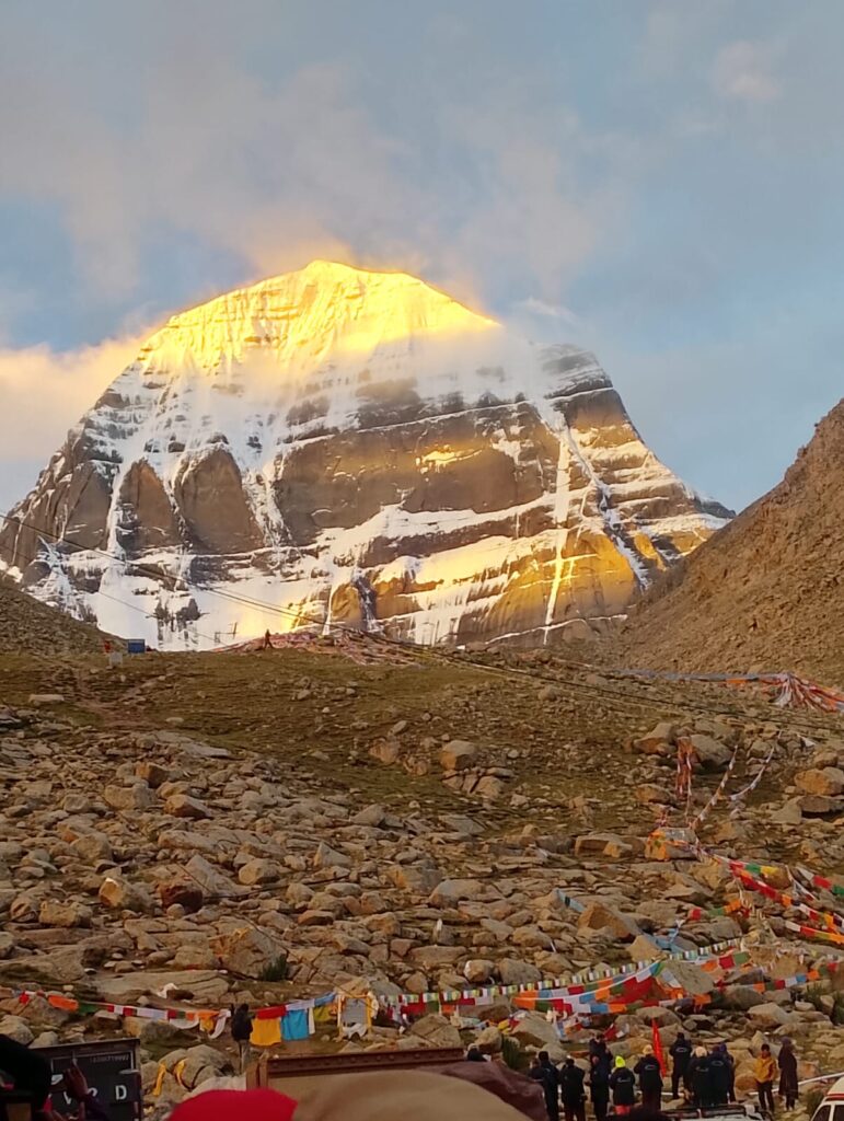
The sacred Mount Kailash Parikrama begins today.
A short vehicle journey takes you from Darchen to Yama Dwar, traditionally regarded as the gateway to the Kora. From here, the journey continues on foot.
The trail follows the valley toward Dirapuk, with the northern face of Mount Kailash gradually becoming more prominent. The scenery is magnificent, but the altitude makes even moderate walking demanding.
Arrive at Dirapuk and rest for the night beneath the spectacular Himalayan landscape.
Highlights: Yama Dwar, first major views of Mount Kailash and Dirapuk.
Day 09: Dirapuk – Dolma La – Gauri Kund – Zuthulpuk
- Altitude: Dirapuk approx. 4,900 m → Dolma La approx. 5,630 m → Zuthulpuk approx. 4,790 m
- Trek: Approx. 20–22 km
- Walking: Approx. 8–10 hours
- Overnight: Zuthulpuk
This is the most demanding day of the entire pilgrimage.
The trail climbs from Dirapuk toward Dolma La Pass, the highest point of the Kailash Parikrama at approximately 5,630 meters. The ascent is steep and slow, with the high altitude making every step more strenuous.
After crossing Dolma La, the trail descends toward the area of Gauri Kund and continues through the valley toward Zuthulpuk.
The combination of altitude, cold, uneven terrain and a long walking day requires patience and careful pacing.
Highlights: Dolma La Pass, Gauri Kund and spectacular high-altitude landscapes.
Day 10: Zuthulpuk – Complete Kailash Kora – Darchen
- Altitude: Zuthulpuk approx. 4,790 m → Darchen approx. 4,670 m
- Trek: Approx. 7–9 km
- Walking: Approx. 3–4 hours
- Overnight: Darchen
The final section of the Parikrama is comparatively shorter.
Walk through the Zuthulpuk valley before reaching the roadhead, where your vehicle will meet you for the return to Darchen.
With this section completed, you finish the approximately 52-km Mount Kailash Kora, depending on the officially designated trail and current route conditions.
The afternoon is kept free for recovery and rest after completing the pilgrimage.
Highlights: Final Kora section, Zuthulpuk valley and completion of Mount Kailash Parikrama.
Day 11: Darchen – Saga
- Altitude: Darchen approx. 4,670 m → Saga approx. 4,600 m
- Distance: Approx. 450–500 km
- Driving: Approx. 8–10 hours
- Overnight: Saga
After breakfast, begin the return journey across the Tibetan Plateau.
The long drive provides a quieter day after the demanding Kailash Kora. Enjoy the changing scenery as the route gradually retraces its way toward Saga.
Overnight in Saga.
Highlights: Tibetan Plateau and relaxed return journey after the Kora.
Day 12: Saga – Nyalam
- Altitude: Saga approx. 4,600 m → Nyalam 3,750 m
- Distance: Approx. 250–260 km
- Driving: Approx. 7–9 hours
- Overnight: Nyalam
Continue eastward toward Nyalam.
As the road descends from the Tibetan Plateau, the reduction in altitude usually makes the journey more comfortable. After arriving in Nyalam, take time to relax and prepare for the following day’s border crossing.
Highlights: Return across the Tibetan Plateau and gradual descent toward Nyalam.
Day 13: Nyalam – Zhangmu – Kodari
- Altitude: Nyalam 3,750 m → Zhangmu approx. 2,300 m → Kodari approx. 1,750 m
- Distance: Approx. 40–50 km
- Driving: Approx. 2–4 hours, excluding border formalities
- Overnight: Kodari or nearby Nepal
After breakfast, descend from Nyalam toward Zhangmu.
Complete the required Tibet-side exit procedures before crossing back into Nepal through the Kodari frontier. The dramatic change in landscape is noticeable as you leave the dry Tibetan environment and descend toward the greener Himalayan valleys.
Border procedures may take additional time, so the day’s schedule should remain flexible.
Highlights: Nyalam descent, Zhangmu and return to Nepal.
Day 14: Kodari – Kathmandu
- Altitude: Kodari approx. 1,750 m → Kathmandu 1,350 m
- Distance: Approx. 125–130 km
- Driving: Approx. 4–6 hours, depending on road conditions
- Overnight: Kathmandu
After breakfast, drive from Kodari back to Kathmandu along the Arniko Highway.
The Kailash Mansarovar Overland Tour via Kodari, Zhangmu and Nyalam comes to an end when you arrive in Kathmandu.
Depending on your international flight schedule, you may continue your journey the same day or spend an additional night in Kathmandu.
Highlights: Scenic Himalayan drive and completion of the pilgrimage journey.
Optional Day 15: Buffer Day in Kathmandu
- Altitude: 1,350 m / 4,430 ft
- Overnight: Kathmandu
An additional day in Kathmandu is recommended for international travelers.
High-altitude journeys can be affected by border formalities, road conditions, weather, vehicle delays and changing local regulations. Keeping one spare day provides useful flexibility before an international departure.
You can also use this day to relax, shop for souvenirs or explore Kathmandu’s cultural heritage.
Kailash Mansarovar Route and Altitude Overview
The journey involves a dramatic elevation transition:
| Location | Altitude |
|---|---|
| Kathmandu | 1,350 m |
| Kodari | 1,750 m |
| Zhangmu | 2,300 m |
| Nyalam | 3,750 m |
| Saga | Approx. 4,600 m |
| Lake Mansarovar | Approx. 4,590 m |
| Darchen | Approx. 4,670 m |
| Dirapuk | Approx. 4,900 m |
| Dolma La | Approx. 5,630 m |
| Zuthulpuk | Approx. 4,790 m |
Zuthulpuk – approx. 4,790 m
The most significant physical challenge is not the road distance but the altitude. Proper acclimatization in Nyalam and a slow walking pace during the Kora are essential.
2026 Border and Route Advisory
The August 2026 flood in Rasuwa has made the Nepal–China border situation unusually dynamic. The Rasuwagadhi–Kerung corridor suffered major damage, while the Kodari/Tatopani crossing has also faced temporary restrictions because of landslide concerns.
For this reason, the Kodari–Zhangmu itinerary should not be promoted as a guaranteed departure route until the relevant authorities officially confirm its reopening for international pilgrimage travel.
Once approved, however, the route provides a distinct geographical alternative to the Rasuwagadhi–Kerung corridor:
- Kerung route: Kathmandu → Rasuwagadhi → Gyirong → Saga
- Kodari route: Kathmandu → Kodari → Zhangmu → Nyalam → Saga
The two routes enter Tibet through different border corridors, making Kodari strategically important when conditions allow.
Final Thoughts
The Kailash Mansarovar Overland Tour via Kodari–Zhangmu–Nyalam is a journey through history, Himalayan wilderness and sacred landscapes. From the hills of Kathmandu to the high Tibetan Plateau, every stage brings a noticeable change in scenery, culture and altitude.
The route’s history makes it particularly meaningful. Once a principal gateway for Nepal–Tibet travel, the Kodari crossing was heavily affected by the 2015 earthquake and later overshadowed by the Kerung corridor. The extraordinary border disruptions of 2026 have once again placed alternative Himalayan gateways under close attention.
For pilgrims, the ultimate destination remains the same: the sacred waters of Lake Mansarovar and the majestic presence of Mount Kailash. The three-day Parikrama, culminating in the demanding crossing of Dolma La, becomes the spiritual heart of the journey.
Because border conditions remain subject to change, travelers should plan this itinerary with flexibility and rely on the latest official confirmation before departure. When the Kodari–Zhangmu crossing is officially open for pilgrimage travel, this historic route can offer a memorable and distinctive way to reach the sacred landscapes of western Tibet.
Trip Highlights
- Historic Kodari–Zhangmu–Nyalam Route – Follow one of the traditional Nepal–Tibet overland gateways toward Mount Kailash.
- Scenic Arniko Highway Drive – Travel through Nepal’s dramatic Himalayan hills, river valleys and mountain landscapes.
- Cross the Nepal–Tibet Border at Kodari–Zhangmu – Experience the historic Himalayan frontier when officially open for pilgrimage travel.
- Acclimatization in Nyalam – Spend valuable time adjusting to the high-altitude environment before heading deeper into Tibet.
- Explore the Vast Tibetan Plateau – Enjoy spectacular views of barren mountains, highland plains and distant snow peaks.
- Sacred Lake Mansarovar – Visit one of the most revered pilgrimage lakes in the Himalayas, surrounded by magnificent mountain scenery.
- Panoramic Views of Mount Kailash – Witness the sacred peak from different sections of the pilgrimage route.
- Visit Darchen – Reach the traditional gateway and preparation point for the Mount Kailash Parikrama.
- Complete the Mount Kailash Kora – Undertake the approximately 52-km three-day pilgrimage around the sacred mountain.
- Walk to Dirapuk Monastery – Enjoy spectacular views of the northern face of Mount Kailash.
- Cross Dolma La Pass – Reach the highest point of the Kora at approximately 5,630 m, the most challenging section of the pilgrimage.
- Experience Gauri Kund – Pass through one of the spiritually significant locations associated with the Kailash pilgrimage.
- Tibetan Buddhist and Himalayan Culture – Experience the distinctive spiritual traditions, monasteries and landscapes of the Tibetan Plateau.
- High-Altitude Himalayan Adventure – Combine an overland journey, sacred pilgrimage and challenging mountain walking in one unforgettable expedition.
- Alternative to the Kerung Corridor – When officially operational, the Kodari route provides a separate Nepal–Tibet border approach from the flood-affected Rasuwagadhi–Kerung corridor.
- Experienced Pilgrimage Support – Travel with an organized team for transportation, border formalities, accommodation, acclimatization and high-altitude assistance.
- Flexible Itinerary for Changing Conditions – Allow flexibility for weather, road conditions, border procedures and official Tibet travel regulations.
Frequently Asked Questions
1. What is the total distance of the Kailash Mansarovar Overland Tour via Kodari?
The complete journey from Kathmandu through Kodari, Zhangmu, Nyalam, Saga, Lake Mansarovar and Darchen, followed by the return to Kathmandu, covers more than 2,000 km by road. The exact distance may vary depending on the approved route, road conditions, border procedures and local diversions.
2. How is the Kodari route different from the Kerung route?
The two routes use different Nepal–China border corridors. The Kodari route follows Kathmandu–Kodari–Zhangmu–Nyalam, while the Kerung route follows Kathmandu–Rasuwagadhi–Gyirong–Saga. After reaching Saga, the routes generally converge toward western Tibet and the Kailash region.
3. Why is the Kodari–Zhangmu route historically important for Kailash Yatra?
Kodari was one of the traditional land gateways between Nepal and Tibet. Before the 2015 earthquake, many pilgrims traveling from Kathmandu to Mount Kailash used this corridor. The earthquake severely disrupted the route, after which the Kerung corridor became increasingly popular.
4. Is the Kodari border currently open for Kailash Mansarovar pilgrims?
The route should not be considered automatically open. Border access can change because of landslides, floods, security conditions, construction and government regulations. Travelers should obtain current official confirmation before booking a departure through Kodari.
5. What are the road conditions on the Kodari–Nyalam route?
The Nepal section includes winding mountain roads, steep slopes and areas vulnerable to landslides. After entering Tibet, the roads are generally more developed, but high-altitude weather, rockfalls and road maintenance can still cause delays. Travelers should expect changing road conditions rather than a completely smooth journey.
6. How many days are required for the Kailash Mansarovar tour via Kodari?]
A well-paced overland itinerary generally takes around 14 days, including acclimatization, the Lake Mansarovar visit and the three-day Kailash Parikrama. An additional buffer day is recommended because border and weather-related delays are possible.
7. How many kilometers do pilgrims walk during the Mount Kailash Kora?
The complete Parikrama is approximately 52 km and is normally completed over three days. The longest and most difficult section is the second day, which includes the climb toward Dolma La Pass.
8. What is the highest point of the Kailash Mansarovar pilgrimage?
The highest point is Dolma La Pass, at approximately 5,630 meters (18,470 ft) above sea level. This is also the most physically demanding part of the Kailash Kora.
9. How difficult is crossing Dolma La Pass?
Dolma La is challenging because of its high altitude, steep ascent, cold temperatures and potentially changing weather. No technical climbing skills are normally required, but travelers need good physical preparation, proper acclimatization and a slow walking pace.
10. What is the significance of Gauri Kund during the Kailash Kora?
Gauri Kund is a sacred location encountered after crossing Dolma La. In Hindu tradition, it is associated with Goddess Gauri (Parvati) and holds considerable spiritual importance for pilgrims. Its location in the rugged high-altitude landscape adds to the religious significance of the journey.
11. What altitude should I expect during the Kailash Mansarovar tour?
The journey begins at approximately 1,350 m in Kathmandu and gradually reaches more than 4,500 m in western Tibet. Lake Mansarovar is around 4,590 m, Darchen approximately 4,670 m, and Dolma La approximately 5,630 m.
12. How can I reduce the risk of altitude sickness during the Kailash Yatra?
The best approach is gradual acclimatization, adequate hydration, sufficient rest and a slow pace. Spending extra time in Nyalam at around 3,750 m is particularly valuable before traveling deeper into Tibet. Serious symptoms should never be ignored, and descent may be necessary.
13. Is there mobile network and internet access during the journey?
Mobile coverage is not available continuously. Larger towns such as Nyalam and Saga may have connectivity, while remote parts of the Tibetan Plateau and Kailash Kora can have little or no signal. Internet speeds and Wi-Fi availability can also be inconsistent.
14. Do we travel by bus or jeep during the Kailash Mansarovar tour?
Most of the road journey is completed by tourist bus, minibus, coach or suitable 4WD vehicles, depending on group size and local road conditions. The Kailash Parikrama itself is primarily completed on foot, with vehicles used to reach the designated trailhead and return point.
15. What type of accommodation is available along the Kailash route?
Accommodation ranges from comfortable hotels in Kathmandu and larger towns to simpler guesthouses and basic facilities in remote pilgrimage areas. Travelers should be prepared for simple high-altitude accommodation, particularly around the Kailash Kora.
16. What kind of food is available during the Kailash Mansarovar journey?
Meals are generally simple, nutritious and suitable for high-altitude travel. Depending on the location and tour package, meals may include rice, dal, vegetables, noodles, soup, potatoes, bread and Tibetan-style dishes. Vegetarian meals can generally be arranged for pilgrimage groups.
17. Are hospitals and medical facilities available along the route?
Medical facilities are limited as the journey moves deeper into Tibet. Nyalam and Saga have better access to medical services than the remote Kailash region. There are no full-service hospitals beside the Kora trail, so travelers should carry personal medicines and travel with an organized support team.
18. Is emergency rescue available around Mount Kailash?
Emergency assistance depends on the location, weather, local authorization and accessibility. Evacuation arrangements cannot be guaranteed in the same way as in urban areas. Travelers should have comprehensive insurance covering high-altitude trekking and emergency evacuation.
19. Will language be a problem during the Kailash Mansarovar Yatra?
Usually not when traveling with an organized group. Nepali is commonly used on the Nepal side, while Tibetan and Mandarin are widely spoken in Tibet. Guides and local staff assist with transportation, accommodation, meals and border procedures, although communication can be more difficult in remote areas.
20. What should I know before choosing the Kodari–Zhangmu route in 2026?
The most important point is that border availability must be confirmed before departure. The 2026 flood severely affected the Rasuwagadhi–Kerung corridor, while the Kodari/Tatopani corridor has also experienced restrictions because of landslide concerns. Therefore, the Kodari route should be promoted as a potential alternative corridor, subject to official reopening and approval, rather than as a guaranteed route.
Ramchandra Lamichhane
Trekking Expert
No hidden fees • Local experts • Best price guarantee